Urban Oases or Heat Islands? Precipitation, Land Cover, and Soil Texture as Factors Associated with Surface Thermal Contrasts in Brazilian Semiarid Cities
Abstract Urban climatology interprets cities as warmer than their surrounding areas, but in seasonally dry environments this pattern can reverse, forming oasis-like conditions. In the Brazilian semiarid, where the Caatinga responds strongly to precipitation seasonality, these patterns remain poorly documented. This study examined factors associated with the intensity of the surface thermal contrast (SHI) in 12 cities, integrating daytime Landsat Collection 2 temperatures (1996–2024), NASA POWER precipitation, MapBiomas land cover, and Embrapa soil data in Google Earth Engine, and evaluated SHI...
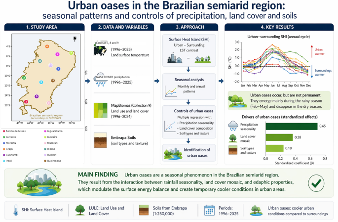
Abstract Urban climatology interprets cities as warmer than their surrounding areas, but in seasonally dry environments this pattern can reverse, forming oasis-like conditions. In the Brazilian semiarid, where the Caatinga responds strongly to precipitation seasonality, these patterns remain poorly documented. This study examined factors associated with the intensity of the surface thermal contrast (SHI) in 12 cities, integrating daytime Landsat Collection 2 temperatures (1996–2024), NASA POWER precipitation, MapBiomas land cover, and Embrapa soil data in Google Earth Engine, and evaluated SHI seasonality, associations with land use and land cover (LULC) classes, and variation across soil texture classes in surrounding Savanna formations. Results showed strong heterogeneity among cities. Spring presented the clearest reversal of the thermal contrast, and summer precipitation showed the most robust association with SHI in the leave-one-city-out analysis. Savanna Formation showed the lowest SHI values, while pastures and land-use mosaics showed higher values. Medium-texture soils showed the most negative SHI values in Savanna areas, but this pattern was not statistically significant. Building shadow cover (mean 8.0%) and the albedo and emissivity of surrounding areas showed no significant association with SHI. These results indicate that daytime urban oases in the Brazilian semiarid are conditional patterns, and that surrounding landscape properties are active components of the urban-surroundings thermal contrast. Graphical Abstract This visual summary presents a synthesis of the fundamental data, analytical structure, and main results of the study. Data: The study integrates 29 years of daytime land surface temperature images from Landsat Collection 2 (1996–2024) processed in Google Earth Engine, NASA POWER precipitation records, MapBiomas land cover classifications, and Embrapa soil data for 12 Brazilian semiarid cities. Analyses: Three analytical dimensions were combined: the association between the surface heat island intensity (SHI) and hydroclimatological seasonality; the relationship between dominant land use and land cover (LULC) classes and urban-surroundings surface thermal contrasts; and the variation of SHI across soil types and textures in surrounding Savanna formations. Model: A comparative observational design at local scale was adopted, quantifying the urban-surroundings SHI index, defined as the difference between mean urban and surrounding surface temperatures, at annual and seasonal scales. Results: Urban oasis-like surface patterns were observed but are neither universal nor permanent. Spring showed the clearest median reversal; summer precipitation showed the most robust seasonal association with SHI; Savanna Formation showed lower SHI values; and medium-texture soils were associated with more negative SHI values in surrounding areas, although the textural pattern was not statistically significant. Conclusion: Urban oases in the Brazilian semiarid are best interpreted as conditional daytime surface patterns, associated with precipitation seasonality, land cover mosaic, and edaphic context, highlighting the need for integrated climate adaptation approaches in cities of arid regions.
Imported from OpenAlex · View original